OUTREACH PROGRAMS
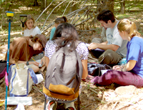
 Forest Watch
introduces K-12 teachers and their students to field, laboratory, and satellite data analysis methods of assessing the health of local forests.
Our New England-wide teacher-training workshops offer hands-on techniques of evaluating the health of white pine (Pinus strobus), a known bio-indicator for tropospheric or ground-level ozone damage. Using these techniques, our Forest Watch teachers then actively engage students in this scientific research project. The data are collected and compiled in a regional survey of white pine health in New England. Forest Watch currently includes schools in six New England states as well as parts of New York and Maryland.
Project SMART
is a month-long UNH summer residential program for high school sophomores and juniors. Students enroll in a discipline-based module designed to expose them to on-going research activities in Space Science, Environmental Science, Biotechnology, and Chemistry.
 Faculty from research centers across the University offer students the opportunity to explore fields of science not generally offered in high school curricula. The program includes interdisciplinary lectures, demonstrations, field trips, and an authentic research experience in which students collect and analyze data and present their findings in the form of oral presentations and scientific posters.
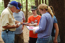
GIS Day
is a UNH event conducted during National Geography Awareness week. The guests: hundreds of high school juniors and seniors, home-schooled students from all over Northern New England, Geo-Spatial Science professionals, university level students and the general public.
GIS Day includes an extensive cartographic exhibition, a Geo-Spatial Science college fair, a vendor hall and informaton on Geo-Spatial Science careers. Attractions have included the "Earth from Space" NASA Satellite Imagery collection, the Library of Congress Antique Map collection, and an 11-foot EarthBall globe. Presenters have included former US Astronaut Dr. Jay Apt, and President of the Amer. Society of Photogrametery and Remote Sensing, Dr. Russell Congalton.
GLOBE Carbon Cycle Education Project
joins NASA carbon cycle science with the international GLOBE education community to bring cutting edge research and research techniques in the field of terrestrial ecosystem carbon cycling into K-12 classrooms. By participating in GLOBE Carbon Cycle students learn to use a systems thinking approach,
while at the same time, gaining a foundation in the carbon cycle and it’s relation to climate and energy. Project materials incorporate a diverse set of activities geared toward upper middle and high school
students with a variety of learning styles. A global carbon cycle adventure story and game let students see the carbon cycle as a complete system, while introducing them to systems thinking concepts. Classroom photosynthesis experiments and field measurements of schoolyard vegetation brings the global view to the local level. And the use of computer models at varying levels of complexity (effects on photosynthesis, biomass and carbon storage in global biomes, global carbon cycle) not only reinforces systems concepts and carbon content, but also introduces students to an important scientific tool necessary for understanding climate change.
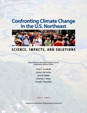 Northeast Climate Impacts Assessment
Confronting Climate Change in the U.S. Northeast: Science, Impacts, and Solutions (PDF): A report of the Northeast Climate Impacts Assessment (NECIA), July 2007.
The research summarized in this assessment describes how climate change may affect the Northeast states under two different emissions scenarios. The focus: how emissions choices affect the Northeast's future climate.
The New England Regional Assessment
presents information about climate change, focusing on past, present, and future impacts to the New England region. The study was conducted as part of the  larger U.S. Global Change National Assessment of the Potential Consequences of Climate Variability and Change. Final product: a summary of our current understanding of global climate change, available in pdf format.
The Millennium Ecosystem Assessment (MA)
is an international work program designed to provide decision-makers with scientific information concerning the consequences of ecosystem change for human well-being and the options for responding to those changes.
The assessment was launched by U.N. Secretary- General Kofi Annan in June 2001 and completed in March 2005. Millennium Ecosystem reports synthesize information from scientific literature, datasets, and scientific models, and include knowledge held by practitioners, local communities and indigenous peoples. The findings undergo rigorous peer review. More than 1,300 authors from 95 countries have been involved in four expert working groups; hundreds more worked in sub-global assessments.
Earth Exploration Toolbook (EET)
EOS-WEBSTER is a founding partner in the EET—a collection of case studies or chapters in which users obtain data and use analytical tools to learn more about issues or concepts in Earth science. Screen shots are provided to assist with the software and analytical tools. Each chapter includes a detailed list of equipment needed (typically software) to complete the chapter. Chapters also identify the National Science Education Inquiry and Content Standards addressed and conclude with suggestions for further exploration.
Intergovernmental Panel on Climate Change (IPCC) -
IPCC has been established by WMO and UNEP to assess scientific, technical and socio- economic information relevant for the understanding of climate change, its potential impacts and options for adaptation and mitigation. It is open to all Members of the UN and of WMO.
Intergovernmental Panel on Climate Change (MVH)
The MVH project is a joint informal education effort conducted by Boston Museum of Science, The Lawrence Hall of Science at UC Berkeley, the University of New Hampshire (CSRC and EOS-WEBSTER), and Indiana State University. The project, designed to introduce the public to the concept that satellites work by measuring light reflected from Earth's surfaces, proposes to develop materials available as:
1. Stand-alone learning activities for use on an "as needed" basis,
2. Learning activities incorporated into a school's curriculum, and
3. Experiential activities for use at a museum, science center, arboretum, botanical garden, or a National Park Service center.
New England Science Center Collaborative (NESCC)
Volunteer training workshops will be developed in collaboration with the NESCC, a network of well over 30 member science museums such as the McAulliffe Planetarium, the Seacoast Science Center and the New England Aquarium. While its focus has been on New England, the Collaborative has developed an effective series of day-long training workshops presented by members of the CSRC that will serve as a model for development at the National scale. The purpose of this collaborative effort is focused on educating the public via exhibits, kiosks, and speaker series.
EOS-WEBSTER
EOS-WEBSTER provides free, customized Earth Science data to the research community, educators, policy makers, and the general public. Our data holdings can be searched spatially, temporally, or by keyword, freetext, or collection name. EOS-WEBSTER has distributed over 100,000 data products to our users world-wide since 1999. EOS-WEBSTER has recently begun to develop classroom-friendly access to free satellite data that now widely used by teachers and their students. Teamed with Forest Watch teachers, this Web-based educational tool has been tested and evaluated for use in educating the next generation of Earth System scientists.
EDUCATIONAL PROGRAMS
Research & Discover
Research & Discover
is a summer internship/fellowship program based at UNH and NASA-Goddard Space Flight Center. The two-summer internship program is available to students who have completed their junior year in college. Following this internship, participants will be eligible to apply for a two-year fellowship in conjunction with graduate studies at UNH. For details and application information, visit http://www.eos.unh.edu/ResearchAndDiscover. This innovative approach to engaging the best and brightest undergraduate students in the study of Earth-related science has proven to foster strong graduate-level Masters projects.
Earth System Science course
Funded by a grant from NASA, the Earth System Science course and course materials are peer reviewed by NASA scientists and education specialists. It provides an introduction to the study of Earth as an integrated system. We introduce major components, interactions, and concepts for characterizing the contemporary Earth System (e.g. spheres, cycles, energy balance, equilibrium, feedbacks, linear and non-linear dynamics). Each lecture builds on information necessary to address advanced themes in recent scientific literature (e.g. non-linear systems, thresholds in metastable systems. Research scientists from NASA who work in the field of Earth System Science present guest lectures. Labs focus on building computer models of key Earth System interaction.
Inquiry-based Remote Sensing
Earth Systems Research Center, in collaboration with the UNH Department of Education, has developed an upper-level undergraduate and graduate level inquiry-based course on remote sensing methods. Students gain familiarity with tools ranging from field-portable reflectance spectrometers to image processing software used to conduct image analysis on data for the Durham, NH area.
This course is offered as the second in a two-course sequence, following the Earth System Science course. It provides remote sensing tools needed by students to conduct research on local topics of interest. Investigations might include local examples of change-over-time, landscape-level impacts of urban development, severe weather events, and other natural and anthropogenic perturbations.